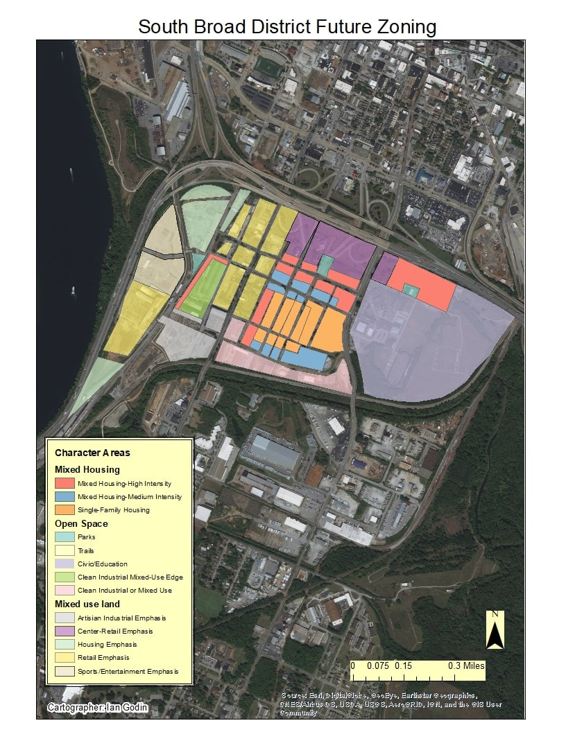
Chattanooga, a city with a population of nearly 180,000 citizens, is located on the banks of the Tennessee River in southeastern Tennessee, just north of the border shared with Georgia. The city is the fourth largest in Tennessee and one that has a rich and vibrant history which started with the Native Americans who populated the area for thousands of years using it as prosperous hunting grounds before they were forcibly removed in the early 1800’s. Chattanooga later played a vital role in the American Civil War as it was considered the “gateway to the deep south” were multiple rail lines converged within the city making it a vital transportation hub. During the war Chattanooga suffered greatly and the city began to crumble, after the war ended in 1865 Chattanooga rebuilt and gained its traction with success in lumber and steel production given its proximity to the Tennessee River. Years later in the mid to late 1900’s, Chattanooga began to experience a rapid increase in population which lead to city expansion and much prosperity, as was the case with many cities at the time. Beginning in the 1980’s and continuing to the present, Chattanooga has see large scale redevelopment and gentrification throughout much of the city (Castor). The most obvious and notable example of this is the downtown core of Chattanooga which is a prime example of “successful” gentrification, other examples within the city are the Riverfront park, the North Shore, and the Art District. One of the target areas for future redevelopment is the South Broad District, located just south of highways 24 and 27 as well as the downtown area (highlighted below in Figure 1).

Figure 1: South Broad District
The South Broad District has been identified as a priority area given its current situation which will be addressed later. Urban planners including the Chattanooga Design Studio, Common Ground Urban Design and Planning, and the Noell Consulting Group have worked together in order to generate a comprehensive planning report (released on February 19, 2018) as well as a market analysis on the district in an attempt to get the ball rolling and create a long-term vision for the revitalization of the district. There are six primary cores within the city of Chattanooga, the important question being asked is after redevelopment weather or not the South Broad District can compete with them and potentially become one of the top four cores.
The new plan for the South Broad District came as a result of a 2007 zoning study conducted by the Chattanooga/Hamilton County regional planning agency. It was determined that the new plan should allow for more mixed use development as opposed to the existing zoning. Much of the current area in the neighborhood is abandoned industrial buildings and open space, which make the district seem isolated from the rest of the city. The current plan has the district divided into several mixed use development zones known as character areas, with each zone promoting a different emphasis. This will allow for multiple types of development to take place and make the neighborhood more connected and integrated with the surrounding city.
The main goals of the South Broad District Redevelopment plan are simple. The developers want to revitalize the South Broad District while simultaneously giving it the change and investment necessary to become a core part of the Chattanooga area. While the developers hope to bring a significant amount of change to the district, they are also trying to preserve what already exists. Through the revitalizing old historic business structures, building of affordable housing and guaranteeing of maintaining of local establishments like the many churches, the developers hope to keep the people and history of the district in place while expanding and growing the districts economic foothold in the Chattanooga area. Their long term goal is to develop the South Broad District into the sixth main area of economic development and power within the city of Chattanooga.
Zoning and Land Use
The re-development of the South Broad district will change the areas existing land use as well as its zoning. Plans were put into place as a result of the 2003 development man created by the Hamilton County Regional Planning Agency (RPA), who saw potential in re-purposing the industrial area. In 2007, the RPA conducted a zoning study of the South Broad district which determined that the best course of action would be to rezone various sections of the district to an Urban General Commercial or UGC classification. This classification allows for a variety of urban mixed use development, which aligns with the overall goals for the district.
The implementation of the UGC classification allows developers and planners to incorporate a wide variety of land uses into a concentrated area. This explained in the South Broad district redevelopment plan in which the neighborhood is divided into several sections known as character areas, or areas of similar land use that are further divided into sub-categories to highlight specific emphasis. These character areas are as follows
· Mixed Use- Mixed use character areas incorporate a combination of housing, retail, entertainment and light industry. These areas also have a strong emphasis on urban living, with buildings being built closer to sidewalks and parking lots being built behind or away from buildings. Single story buildings are discourage to promote more development in a smaller space. This helps the neighborhood seem more interconnected and more accessible to pedestrians.
· Mixed Housing- Housing will be incorporated across the re-developed district, however Mixed Housing character areas will specifically have a residential emphasis with varying levels of intensity. High intensity housing areas will be located adjacent to mixed use land or the interstate. Medium intensity housing will be located along the edges of corridors or open spaces. Low intensity housing will be located on streets within the neighborhood away from mixed use retail and entertainment areas. Each of these intensity areas will be integrated through a street network with the overall goal of eliminating the “apartment complex” style of housing which tends to isolate developments from their surroundings.
· Industrial- Industry and manufacturing had a strong foothold in the South Broad Street district and will also a role, although not as significant, in the re-developed district. The industrial character areas will emphasis clean industry with buildings and warehouses that conform to the mixed use design (storefronts at sidewalk level facing street, large vehicles must remain behind the building.)
· Civic- The only Civic character area in the re-development plan is the area around Howard School, although others will be welcome for development. Civic buildings will need to be well connected to other character areas and stand out more prominently than surrounding buildings.
· Open Space- The final character areas that will be included in the re-development project are Open Space areas. These areas include parks, nature preserves and green spaces. Open spaces are important in any urban environment and will be incorporated throughout the district. A necessary aspect of planning open spaces is to design them with a specific purpose in mind rather giving left over space this designation.
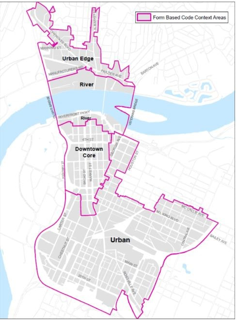
Traditional vs. Form Based Code Zoning
The plans in place for the South Broad District fall under the category of Form Based Code Zoning, which focuses on the appearance and placement of buildings in relation to the space around them rather than land use alone. This type of zoning has already been implemented in several neighborhoods of chattanooga. Traditional zoning focuses on segregating buildings based on land usage (i.e. residential, industrial, commercial). Form based code allows multiple types of buildings to be built in close proximity, however all buildings must adhere to the code. In terms of the South Broad District, the new code allows for mixed-use development, however all buildings must be constructed with facades facing the street and building entrances being closer to sidewalks to promote walkability.
The Form Based Code Institute (FBCI) has distinguished 5 main elements of Form Based Codes, which include the following.
· Regulating Plan-, this is a plan or map showing where different building standards apply. This is seen in the map of the South Broad District plan showing different character areas.
· Public Standards- This refers to regulations regarding public areas such as streets, sidewalks and storefronts
· Building Standards-This refers to regulations regarding buildings, such as how they are oriented or how many stories may be constructed.
· Administration- This element involves having an effective project application and approval process
· Definitions- This refers to a glossary that clearly define the terms discussed in the project plan.
A benefit of form based codes over traditional zoning is that they allow for flexibility in development while still maintaining some form of organization. For example, in the proposed character areas in the redevelopment plan, mixed use development is allowed, however each area has a particular emphasis. The map below shows areas where form based codes have already been implemented in Chattanooga.
The concept of Form Based Codes align with the planning movement known as New Urbanism. This term refers to the creation of multi-use, compact communities that are more complete and integrated. According to the webpage created to promote the movement, New Urbanism has ten principles, nearly all of which are addressed in the re-development plan, including walkability, connectivity, mixed use & diversity, mixed housing, quality architecture and urban design, traditional neighborhood structure, increased density, smart transportation, sustainability and quality of life. Many of these principles can be seen in the form based code style development planned for the South Broad district. For example, sectioning off the district into character zones will allow for the community to be more connected and integrated. Also, allowing mixed use development will promote walkability and ease of living as necessities such as grocery stores can be built much closer to people's homes.
A major proponent of the South Broad District Redevelopment plan is the concept of building a new minor league baseball stadium on the west side of the district. The stadium would replace the Chattanooga Lookouts’ current stadium in the Riverfront Neighborhood of Chattanooga. Developers believe building a new stadium for the Chattanooga Lookouts would stimulate a large amount of development in the South Broad District (SBD). Research of six other recently built minor league stadiums has shown that an average of 1.1 million square feet of new development is brought within a quarter mile of the new stadiums (SBD Study p13). With more investment and an increase in business traffic, the land values in the district would significantly increase. This catalyst for growth could make the South Broad District a new, sixth, center of growth in the Intown Core of Chattanooga.
The desire for a new stadium comes from desire to leave the highly flawed and aging stadium in the Riverfront Neighborhood, near the Tennessee Aquarium. The current Chattanooga Lookouts stadium is used only 60 days a year. All of these days consisting solely of Chattanooga Lookouts’ home games. The blame for this limited use can be put on the stadiums location and design. The stadium is located on top of a steep hill, limiting accessibility (Figure on the left below). The only means of access to the stadium include a set of large staircases or a steep road. This makes access difficult to those with mobility issues, such as the elderly and handicapped individuals. Along with its location on top of a hill, the stadium is oriented in a way that players and game attendees are exposed to a large amount of sunlight. As a whole the stadium has an old and dated design (Figure on the right below). Attendees are unable to walk around the circumference of the ballpark, much less find a social gathering area other than the stadium bleachers. In similar fashion, the amenities of the entire stadium are dated and small compared to those of modern multi-use stadiums. Overall, the stadium has more faults than strengths.


While the current stadium lacks the access and features needed to compete with modern minor league stadiums, it is located on a highly valuable plot of land. The Riverfront Neighborhood has the highest real-estate value in the city of Chattanooga. With its prime location in close proximity to downtown and many of Chattanooga’s biggest attractions, redevelopment of the stadium would allow more usable and profitable establishments to take its place. With redevelopment of the stadium, the city would also see a notable rise in property tax revenue; giving the city even more incentive to start progress on the South Broad District Redevelopment.
If constructed, the new baseball stadium would fix all of the issues ailing the current stadium, as well as expand on its economic and social role in the newly developed South Broad District. To start, the location of the new stadium is a prime economic development site (Figure _). From this spot, the stadium could act as a catalyst for economic and cultural growth throughout the district. Ending the trend of limited use, the new stadium will be designed in a way that it can be used 300 or more days a year. Whether it’s for Lookouts games, concerts or other event, the stadium will play a bigger role than just being a baseball venue. This multi-use design will attract a larger number of consumers to the area, increasing traffic throughout the district. Businesses can take advantage of this increased traffic, which would be present over ¾ of the year as the stadium hosts events 300+ days a year. With this immense amount of malleable consumer traffic, there should be plenty of opportunity for businesses to thrive in the new South Broad District.
In addition to an increase in business and consumer traffic, the streets themselves will be seeing a drastic increase in automobile and pedestrian traffic. Amongst many of the redevelopment plans in place for the South Broad District, one major component is mobility. Almost every road in the district is being redesigned to better handle the increase in traffic. To appeal to pedestrians, every major road is being redesigned with wider sidewalks, larger planter rows, and designated bike lanes. The reason for all these improvements is because the current state of pedestrian walkways in the district is laughable. Many of the streets have very narrow sidewalks, if they have one at all, that do not appeal to the common pedestrian. After walking around the district this spring, I can say from experience that the current walkability of the district is pitiful (see figures below)


The two largest and busiest roadways in the district are getting the largest overhaul. These streets are South Broad and Market streets. South Broad Street is the main traffic avenue, running north to south, acting as the gate to the economic cores of downtown Chattanooga to the north. Market Street, on the east side of the district, is another major north to south avenue. Market Street is the second most used route for public transportation in the area. With this, developers need to make the district pedestrian friendly from Market Street all the way west to the Stadium if they want people to feel safe and able to use public transit. To make these two major corridors more pedestrian friendly, developers plan to establish or relocate planters or planting strips alongside walks to act as buffers, narrow the roads a small amount to slow the speed of traffic, insert medians where possible, and create dedicated bike lanes with possible designated buffer zones. Other changes are planned to take place as well but their impacts are of lesser significance.
In addition to these two north-south corridors, the two major east-west corridors are also planned to be redeveloped to maximize walkability. These corridors include 26th and 28th Streets. Currently these streets have very narrow, unkempt sidewalks with little to no buffer between the pedestrians and vehicular traffic. While the sidewalks are in need of improvement, these roads do have dedicated bike lanes in place already (Figure below). These corridors would be the main routes of travel between the east and west parts of the district. These corridors are extremely important because they connect the entertainment and sports districts on the west to Market Street, the major public transit route in the district, to the east. To improve the walkability of these streets, the developers plan to add on street parking, a sort of buffer for sidewalks; wider planting strips; wider sidewalks; and a buffer to the bicycle lanes on either side of the street.
In addition to these two north-south corridors, the two major east-west corridors are also planned to be redeveloped to maximize walkability. These corridors include 26th and 28th Streets. Currently these streets have very narrow, unkempt sidewalks with little to no buffer between the pedestrians and vehicular traffic. While the sidewalks are in need of improvement, these roads do have dedicated bike lanes in place already (Figure below). These corridors would be the main routes of travel between the east and west parts of the district. These corridors are extremely important because they connect the entertainment and sports districts on the west to Market Street, the major public transit route in the district, to the east. To improve the walkability of these streets, the developers plan to add on street parking, a sort of buffer for sidewalks; wider planting strips; wider sidewalks; and a buffer to the bicycle lanes on either side of the street.
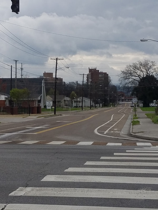
As a whole, developers plan to create a system of A and B streets to help control and protect the flow of traffic throughout the district. ‘A’ streets being primarily pedestrian oriented streets. ‘B’ streets being primarily vehicular oriented streets. With this system developers hope to create corridors and areas where people feel safe to walk around, shop and socialize, while also providing swift and efficient corridors for traffic to enter and exit the South Broad District. Without this cohesion, there would be very little chance for the South Broad District to have success in becoming another developmental and economic core of the Chattanooga area.
It is important to first identify why the South Broad District is considered a prime location for redevelopment and why the current situation is favorable. To address the first point regarding location, the South Broad District is often the first sight tourists or current citizens are greeted with when entering the city of Chattanooga from the south/southwest on Highway 24. Instead of a vibrant, lively, welcoming first look at the booming city of Chattanooga, incomers are faced with the abandoned Wheland and U.S. Pipe Foundry sites (Figures 2 and 3 below).
It is important to first identify why the South Broad District is considered a prime location for redevelopment and why the current situation is favorable. To address the first point regarding location, the South Broad District is often the first sight tourists or current citizens are greeted with when entering the city of Chattanooga from the south/southwest on Highway 24. Instead of a vibrant, lively, welcoming first look at the booming city of Chattanooga, incomers are faced with the abandoned Wheland and U.S. Pipe Foundry sites (Figures 2 and 3 below).


Being situated along the highway is also extremely valuable for the district which will attract big box stores to move into the space then transitioning into mixed use retail and mixed housing. The South Broad District is also located just to the south of the recently redeveloped Southside Historic District as well as downtown, as stated previously the redevelopment of the areas to the north have caused the South Broad District to become disconnected from the rest of Chattanooga. We scheduled a meeting with the Chattanooga Design Studio’s Sally Morrow, an associate architect and urban designer, in order to discuss these in greater detail. During the interview Mrs. Morrow confirmed that if the development were to become finalized and completed, large chain or big box stores would want to be close to the interstate as it is the most visible location when people are passing by. Sally also stated that the vision for the final plan is that the South Broad district will become a “gateway to Chattanooga” from the south, a neighborhood that feels much more connected with the rest of the city, compared to the rundown industrial scene that feels separated and disconnected present today (Morrow). During our time in Chattanooga our group traveled to the South Broad district and experienced this first hand. The neighborhood feels very different than the rest of the city of Chattanooga, especially in comparison to the areas located just to the north which are downtown, the South Side Historic District, and the area surrounding the University of Tennessee at Chattanooga.
The district’s current situation and various circumstances, aside from its location, also make it a favorable target for redevelopment. According to Sally Morrow, there are “major moving parts within the district that are not moving together”, this being the industrial space, residential, retail/small businesses, Southside Gardens, and the Howard School (see figure ???). According to census data collected in 2016, the district as a whole has a population of 326 residents, which is an extremely low population density for a plot of land this size within the city of Chattanooga. A Chattanooga population density map using the natural breaks classification method with slightly adjusted values can be seen below which is based on block group data acquired from the United States Census in 2016 (Figure 4 below).
The district’s current situation and various circumstances, aside from its location, also make it a favorable target for redevelopment. According to Sally Morrow, there are “major moving parts within the district that are not moving together”, this being the industrial space, residential, retail/small businesses, Southside Gardens, and the Howard School (see figure ???). According to census data collected in 2016, the district as a whole has a population of 326 residents, which is an extremely low population density for a plot of land this size within the city of Chattanooga. A Chattanooga population density map using the natural breaks classification method with slightly adjusted values can be seen below which is based on block group data acquired from the United States Census in 2016 (Figure 4 below).

Figure 4
After examining the patterns in figure 4 above, the South Broad district (identified with the bold black border) is classified among the block groups with the lowest population density and has an exact value of 322 residents per square mile (326 total). Using the 2016 Census data an income map was also generated, shown below, figure 5.

Figure 5
The map above is important because it provides a visual that highlights other recently redeveloped areas within the city of Chattanooga, the Southside Historic district, Downtown, and the Northshore, those areas are located just north of the South Broad district and have average income per capita values higher than the areas surrounding them. This poses in interesting question which also relates to one of the goals of the redevelopment plan, would a revitalized South Broad district see substantial success and economic growth as a result of redevelopment and will it be enough to support the people living within the district? The mean per capita income for the South Broad district based on 2016 Census data was just over $12,000 while the mean for the rest of the block groups within Chattanooga is $28,000. Another aspect of the district that also may be useful to examine is the demographic of the area and determine the age groups of the people who live within the proposed redevelopment area. Two maps can be seen below, figure (6) is displaying the 18-34 age group population density within Chattanooga based on 2016 U.S. Census block group data. Figure (7) is displaying the 55 and above age group population as a percentage of the total population within Chattanooga based on 2016 U.S. Census block group data.

Figure 6

Figure 7
Given the information above, the viewer is able to determine that the South Broad district appears to be a neighborhood were the general population is older especially in comparison to that of the surrounding area. The figure above on the left uses the natural breaks classification method and the results showed that the number of people between the ages of 18-34 make up a very small percentage of the population which is 8% of the total population of the South Broad district, the average percentage that this age group makes up per block group is substantially larger at 46%. The figure on the right simply represents what percentage of the total population that the age group 55 and over represents. The results for the South Broad district is that 58% of the population is made up of people 55 and over where the average result for all other block groups within the city of Chattanooga is 31%. These results were interesting to us and after talking with Sally Morrow at the Chattanooga Design Studio we discovered the reason to why this district had averages that were so much higher and lower than the averages of the other block groups within the city. The explanation for the much higher percentage of the population ages 55 and over is large part due to the Mary Walker Towers apartment buildings which are largely inhabited by senior citizens (shown below, figure 8)

Figure 8
While in the neighborhood we also noticed the overall poor state of the existing houses and other structures, many of which were run down, and several appeared to be abandoned or vacant. The figure below illustrates the percentage of total structures built between the years 1960-1969 within each block group for the city of Chattanooga.
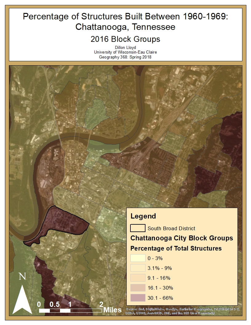
Figure 9
The South Broad district is classified as being in the category with the highest percentage of structures build within that time frame between 49 and 58 years ago. Other block groups also had percentages that were considerably above the average, however many of the structures located in those areas were preserved or renovated historic buildings that are still in use. The resulting values showed that 81 of the 267 structures in the district were constructed during this time (30%), the average for the city was less than half of that, only 13% of the structures were built in the 1960, a majority of those were constructed later. Mrs. Morrow also stated that there are roughly sixty unoccupied or vacant houses within the district as well as vacant lots scattered throughout the district (figures below) (Morrow).


While in the neighborhood we also noticed that there are gaps and an abnormal amount of space between buildings and houses especially in the Southside Gardens area of the district. This is also abnormal for a growing city this size and something that supports the case for this area to become redeveloped in the near future. Much of land that makes up the Southside Gardens area of the district is owned by a very small number (“a couple”) of people and it is reported that they are open to investments and support much of the proposed redevelopment plan. The major property owner in the west side of the district, the Wheland and U.S. Pipe Foundries, is also said to be very interested in redevelopment (Morrow).
 Map of Chattanooga’s South Broad District’s Flood Zone: Photo by FEMA Flood Map Service Center
Current Neighborhood Problems:
The South Broad District is an underdeveloped area in Chattanooga that the Chattanooga Design Studio has selected as an ideal area to revitalize by making it the new location for the Chattanooga Lookouts Baseball Stadium. There is however some issues with this area that the Chattanooga Design Studio and the city are working on solutions for before they are able to move forward with the proposed plan. The South Broad District is bordered by the Tennessee River which is quite susceptible to flooding as well as the Chattanooga Creek which is fed by the Tennessee River and runs through this district. This area often floods after heavy rain storms which makes it difficult to develop. It is currently one of the poorest neighborhoods in Chattanooga. This district is faced with the problem of mass vacancies and homelessness as well as issues concerning street layout and traffic flow.
Visiting the South Broad District it was very apparent that there were many vacant houses in the surrounding area. In our interview with Sally Morrow from the Chattanooga Design Studios who had developed the proposed plan, she told us that there were less than 1000 people living in the whole South Broad District and that this was ridiculous considering the size of the area and the population of Chattanooga as a city. When arriving there this was quite apparent, not only did many houses seem to be vacant but there were also some businesses that seemed to be empty as well. There were some businesses open on the day that we investigated the neighborhood and when asking the store owners about the neighborhood many expressed concern for the state of the current neighborhood. When asked about the proposed plan they were very optimistic about the Chattanooga Design Studio proposed revitalization.
Most of the businesses in the area were focused around interior design and were hopeful that the plan for the new stadium would be implemented in the next few years. The people that we talked to who owned these businesses also expressed some concerns about the current neighborhood. Workers at Stone Source Tiling mentioned that the way the neighborhood was set up it was difficult to access and that there was always issues with traffic since the area had a very poor in and out system and it was difficult to turn around without driving through the whole district. They mentioned that they were in support of the plan to revitalize the area and expected a major boost in business if the plan was passed. Workers at Yessick’s Interior Design expressed some safety concerns about the area, specifically with the number of homeless people in the area which relates back to the massive number of deteriorating and or vacant houses. They also said that they had attended a couple of the city meetings involving the proposed plan and were definitely in support of it. The people we talked to at Classic Cabinetry also mentioned the issues with the accessibility and traffic flow of the area and like the other businesses were in support of the plan.
Besides these shops there were also some chain restaurants, nursing homes and a half dozen churches. There were also some old warehouses that had been abandoned behind the Southside Gardens area in the Wheland and US Pipe Foundries section of the South Broad district. Many of these large industrial building were pretty much stripped bare and left vacant for development. There was a very nice bike path that passed through this area which we saw numerous people utilizing while we were taking picture of the area. It has a lot potential for development but this industrial area is very close to the Chattanooga Creek and the Tennessee River and was in the area’s flood zone.
Sources:
Interview with Sally Morrow - Associate AIA and urban designer at Chattanooga Design Studios
The South Broad District Study and Market Analysis: https://issuu.com/chattanoogadesignstudio/docs/01-29-2018_southbroaddistrictstudy-
Images were taken the authors of this document or taken from the study cited above

Chattanooga Lookouts Current Stadium: Photo by Evan Kebus

Tennessee River: Photo by Evan Kebus
